


please send a mail
-->here<--
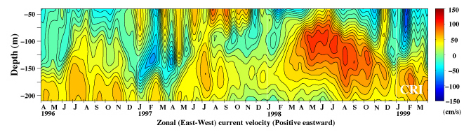
The figure above shows the variations of zonal(east-west) current at 0N(equator)-165E. These are ADCP data and obtained from PMEL, NOAA, U.S.A. The tidal components were rather strong at this location and the low pass filter with the cut off period at 30-day was applied. The eastward (yellow-red) subsurface current below about 100m is the Equatorial undercurrent. This subsurface current shoaled and became very strong in mid-1998 at the onset of La Nina. The red and yellow wedge-like features extending from the surface to about 75-150m were strong eastward currents caused by relatively strong westerly (eastward) wind events called westerly wind bursts and they were quite frequent from late 1996 through late 1997 during last El Nino.
We reserve the copyrights of all the figures shown in our web site. If you want to pass(send a copy) our figures to the third-party, we ask you to do so without getting any thing, either money, goods, preferences and/or anything, in return. Also, we ask you to notify the status of the copyrights of our figures to that third-party. If you want to use entire or parts of our figures, we ask you to show the origin and the status of the copyright explicitly in your documents where our figures are going to be used. We appreciate very much if you let us know your usage of our figures in that case.
Thank you.
CRInternational