


please send a mail
-->here<--
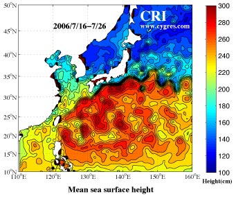
The left figure above shows sea surface height averaged over the period of July 16 through July 26, 2006. The data were obtained from AVISO, France where data from several satellites, such as Topex/Poseidon, Jason-1, ERS and ENVISAT were utilized to construct a global sea surface height data set with 1/3 degree spatial interval both in latitude and in longitude with 3-day time interval.
The contour interval of this figure is too small near the Kuroshio which lies along the area where the sea surface slope is steep, and the Kuro(Black in Japanese)shio(Tide and current in Japanese) south and east of Japan literally appears as a black river.
We made figures of monthly mean sea surface height near Japan from September 2001 to June 2006. Please click the year below to see those figures.
We reserve the copyrights of all the figures shown in our web site. If you want to pass(send a copy) our figures to the third-party, we ask you to do so without getting any thing, either money, goods, preferences and/or anything, in return. Also, we ask you to notify the status of the copyrights of our figures to that third-party. If you want to use entire or parts of our figures, we ask you to show the origin and the status of the copyright explicitly in your documents where our figures are going to be used. We appreciate very much if you let us know your usage of our figures in that case.
Thank you.
CRInternational